

Pendine
Enjoy the views of beaches known for World Land...
A fine walk along the post industrial coastline incorporting the Llanelli Wetland Centre
Paddy Dillon
Llanelli was once an important coal mining centre, specialising in non-ferrous metal manufacture. Tinplate manufacturing survives, but vast industrial sites closed down, along with the town’s docks. Those sites have been used for new housing, a golf course and nature reserves. The Wales Coast Path makes the most of the post-industrial coastline and the Llanelli Wetland Centre can be incorporated into a fine walk.
Distance: 6.9 miles or 11.1 kilometres
Start location: Llanelli Railway Station
Start Grid Ref: SS 50604 99483
Start What 3 Words: brand.chest.plant
Parking
Parking opposite Llanelli Railway Station, Millennium Quay near Seaside and Llanelli Wetland Centre.
Bus
Daily bus services, except Sundays, link Llanelli with Swansea and Carmarthen. Note that the bus station is a mile away from the railway station where the walk starts, so it is better to catch a bus to Seaside to start.
Train
Daily train services to Llanelli from Cardiff and Swansea on the South Wales Mainline, as well as services from Carmarthen on the West Wales Line.
The circular route is marked in dark pink in the map image below. The purple flags show the start and finish point. View the route and download GPX link 'Llanelli'

1. Start at Llanelli Railway Station on Great Western Crescent, where there is a car park opposite. Follow the road past the Mastercabs taxi office then turn left over a level crossing. Notice the blue plaque on the right, marking the site of the Glanmor Foundry, which operated from 1850 to 1979. Keep right at a road junction, then as the road bends left, turn right to follow tarmac paths through a green space, passing between a solitary stone-built house and the Bethel Baptist Chapel. A saucepan sculpture recalls that Llanelli was once nicknamed ‘Sospans’ and a noticeboard offers information about the Llanelli Community Heritage Trail. The route so far has also been following the Heart of Wales Line Trail, marked by little signs and stickers bearing a railway viaduct logo. The trail runs all the way from Llanelli to Craven Arms in Shropshire.
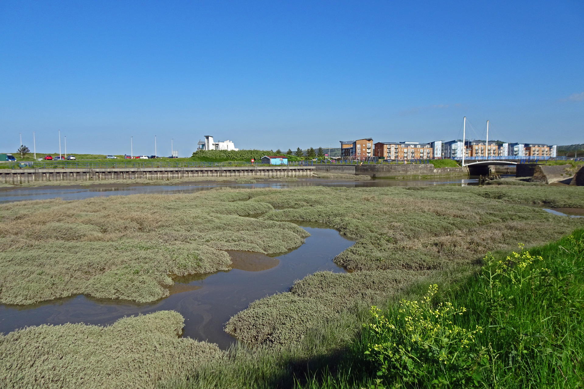
2. Follow the road, Marine Street, onwards past bus shelters. The road bends left and it is best to walk along the pavement on the left-hand side of the road. This becomes a footpath and cycleway passing to the left of a roundabout. Cross over the B4304 Swansea road and turn left, following another footpath and cycleway that is jointly marked as the Heart of Wales Line Trail and the Wales Coast Path. The nearby modern building development is Seaside, but our route leads away from it, alongside the marshes and mudflats of the Afon Lliedi. A notice points out that semi-natural grassland growing between the coast and the main road are covering former industrial sites. Look out for a plaque marking the former Copper Works Dock, which was the first floating dock to be built in Wales, operating from 1824 to 1949.
3. Pass a roundabout and cross a footbridge, then turn right to walk away from the busy B4304 road. A modern housing development occupies a former industrial site, overlooking an old quay and a tidal creek. Turn left round a point and walk round a marshy bay where modern housing faces distant Gower. Pass a plaque recording the site of Machynys Farm. The name Machynys is now used for the new housing development. Turn around another point and walk around another marshy bay. Turn around yet another point, which has a steel pinnacle sculpture on it. This marks one end of the 13 mile Millennium Coastal Park, with the other end marked by a steel pinnacle near Burry Port.
4. Housing gives way to a golf course and a big noticeboard offers information about the Llanelli Community Heritage Trail, Machynys and the lost village and community of Bwlch y Gwynt. Maps show how much of this area was once heavily industrialised. A broad, gritty track passes another marshy bay. After turning a final point, the track drops a little and loses views of the coast, becoming enclosed by brambles, bushes and trees. A concrete sea wall continues, but it is very overgrown, so it is best to stay on the track used by the Wales Coast Path. Pass a large pond that attracts wildfowl, and later cross a wide bridge spanning a drain. The track continues alongside the concrete sea wall, and it is worth climbing onto it to follow a grassy path along the top, or at least to see the extensive marshes beyond. The Wales Coast Path, however, stays on the gritty path and eventually reaches a junction with another path close to the busy B4304 road.
5. A choice of routes is available at this point. Either turn left along a tarmac footpath and cycleway to return to Llanelli, saving 1½ miles of walking, or turn right to follow the Wales Coast Path to visit to the Llanelli Wetland Centre. If making the detour, the gritty path soon becomes a tarmac path and the surroundings are well-wooded, despite the proximity of the busy road. The path eventually crosses a footbridge and joins a traffic-free road. Turn right to follow it, then join another road and turn right to gain access to the Llanelli Wetland Centre car park. Keep well to the right of the car park to find a pedestrian route to the entrance. Note that the wetlands are extensive, threaded by a complex network of paths, and it would be easy to spend the rest of the day there, as well as dining in their cafe. It might be worth finishing the walk here and arranging to be collected at the end of the day.
6. To walk back to town from the Llanelli Wetland Centre, retrace steps back along the Wales Coast Path and switch to the tarmac footpath and cycleway that continues parallel to the busy B4304 road. This passes three very prominent pylons before reaching new housing developments in the suburbs of Llanelli at Hafan y Morfa. Pass to the left of a roundabout, then turn right to cross the main road, before turning left to continue following a footpath and cycleway parallel to the busy road. Walk all the way to the next roundabout and turn right to pass a Lidl supermarket. (Alternatively, look out for a path on the right, before reaching the roundabout, then turn left along a hidden path that runs behind trees to emerge at the roundabout.)
7. The road has generous green verges as well as a tarmac path on the right-hand side, despite being in the built-up suburbs. After passing the Whitstable Inn, New Dock Road features rows of terraced houses, a few shops and a couple of chapels. Despite the houses having been modernised over the decades, many of them have retained the original styles of their doorways. Cross a level crossing, or use a footbridge to cross the railway line, then turn left along Great Western Crescent to finish back at Llanelli Railway Station.


