

Talacre Warren
A great circular walk from Talacre, on a splendid...
Learn about the area's industrial heritage on this short walk with fine views across the Dee Estuary
Paddy Dillon
Bagillt is a small village with an industrial past. It used to be surrounded by coal mines and also supported a lead smelter, foundry and brewery. A short walk along the Wales Coast Path allows some of the industrial heritage of the area to be appreciated, while a small hill of vegetated colliery waste offers a fine viewpoint across the Dee estuary.
Distance: 1.9 miles or 3.1km
Start location: Stag Inn, Bagillt
Start Grid Ref: SJ 21963 75320
Start What 3 Words: fruitcake.either.zoned
Parking
Car park opposite the Stag Inn at Bagillt.
Bus
Daily bus services link Bagillt with Chester, Holywell, Prestatyn and Rhyl.
Train
None, but daily North Wales Coast train services link nearby Flint with coastal stations between Chester and Holyhead.
The circular route is marked in dark pink in the map image below. The purple flags show the start and finish point. View the route and download GPX link 'Bagillt and Bettisfield'

1. Start in the village of Bagillt at the Stag Inn, which has a car park opposite and bus stops nearby, where a noticeboard offers information about the Bagillt Industrial and Heritage Trail.
2. Walk directly from the Stag Inn towards the busy A548 dual carriageway road, and cross carefully by using the path through the central reservation. Continue along Station Road, noting that the old stone wall on the left is all that remains of the Cambrian Brewery, which operated from 1825 to 1893. Use a footbridge to cross the railway line, taking advantage of the height to study the nearby saltmarsh and the Dee estuary. There used to be a railway station, but it closed in 1966 and was subsequently demolished. A community garden now stands close the where the station used to be.
3. The Wales Coast Path is signposted to left and right. Turn right, but only for a few paces, just to read a notice about the Station Gutter, also known as Bagillt Gutter or Bagillt Dock. This narrow, muddy inlet was once busy with flat-bottomed boats carrying coal from the local mines. The Wales Coast Path is signposted for Bettisfield, following a track alongside the saltmarsh, parallel to the railway line. The track gives way to a tarmac road, then a small gate on the left takes the Wales Coast Path along the top of an embankment close to the saltmarsh. Pass a notice explaining about Bettisfield’s Natterjack Toad Reserve. Natterjacks went extinct in Wales in the 1950s, but were reintroduced to this site in 2014.
4. Reach a path junction and turn right as marked for the Wales Coast Path. Pass another notice about natterjacks, stay on the gritty path and go through a kissing gate. When the path splits, keep left and pass the modern Bagillt Stonehenge. The path rises gently and reaches the splendid Bagillt Beacon, fashioned in the shape of a dragon. This was installed at the same time that the Wales Coast Path was opened in 2012. Enjoy views of the surrounding countryside, looking across the Dee estuary to The Wirral. Bear in mind that this pleasant grassy space was once a sterile heap of colliery waste.
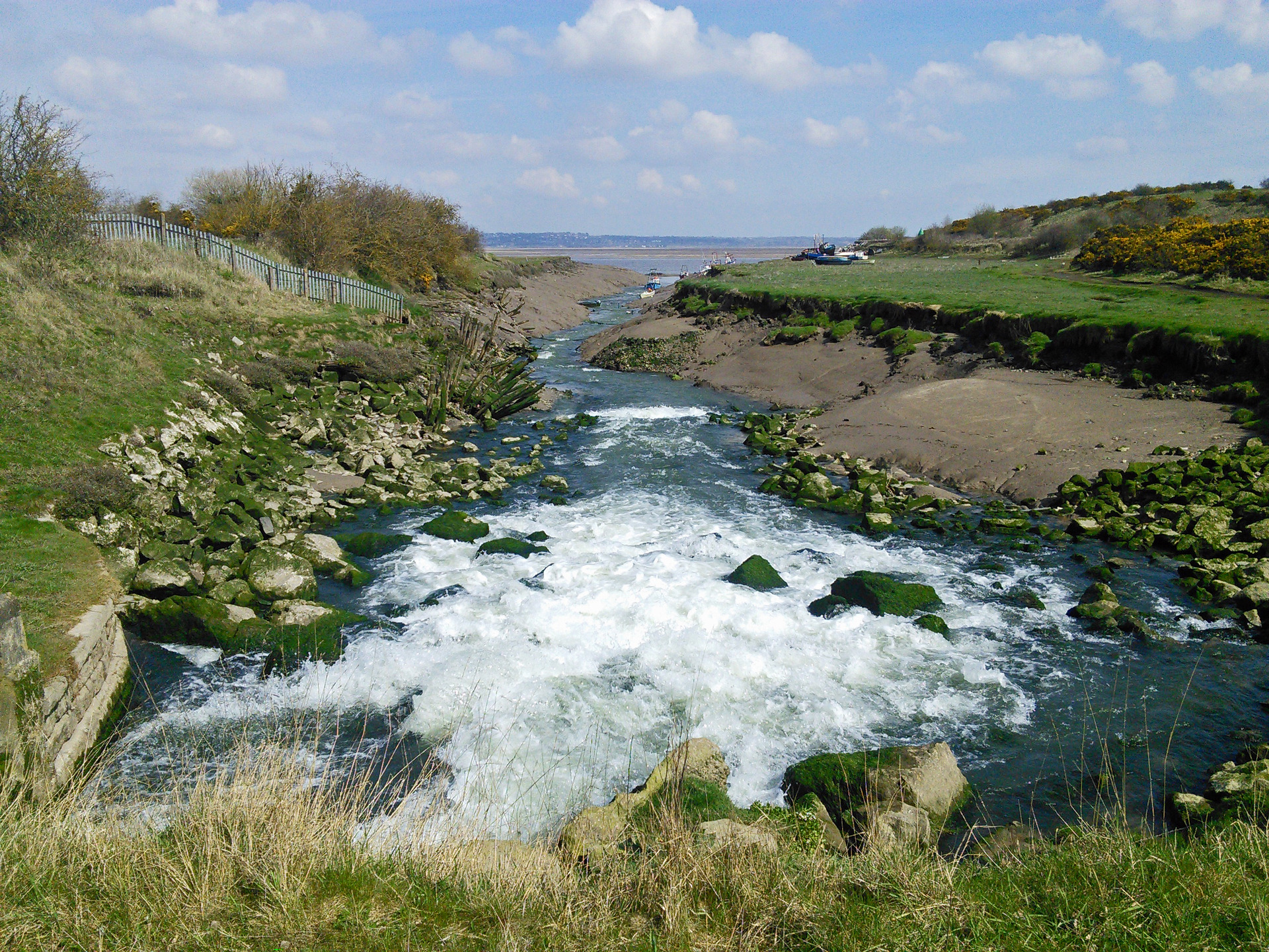
5. Walk straight past the beacon to find a broad, grassy path flanked by fences. This leads down to a curious mining monument, in the shape of a pickaxe that serves as a sundial. Rising beyond is a red-brick building which is all that remains of the Bettisfield Colliery, which operated from 1872 to 1933. If you are in a hurry, walk further downhill and pass the building by road. With a few minutes to spare, however, it is worth making a detour through a small gate close to the monument, turning right along a path running parallel to the road. Cross the road and continue as signposted a short way to reach the Milwr Tunnel, where water gushes towards the estuary. The tunnel extends for 16km or 10 miles inland, draining several old mines beneath Halkyn Mountain.
6. Retrace steps until the path joins the road alongside the red-brick building, now used by a car spares business. Follow the road under a railway bridge and carefully cross the busy A549 dual carriageway road by using the path through the central reservation. This leads to a tiny ‘nature area’ at the start of the quiet High Street that leads straight back into Bagillt. Follow the road past houses, a church and a war memorial garden. Just after the shop/post office is Forresters Hall, which was the first ‘Chocolate House’ established in Wales by the temperance movement, dating from 1879. It has had many uses since that time, including serving alcohol! The Stag Inn comes immediately afterwards, marking the end of the walk.

